Aviosuperficie Boglietto
"Dino Rizzoglio"
"Dino Rizzoglio"
La pista - The airfield


44° 45' 30'' N 8° 11' 00'' E
Altitudine / altitude: 640 ft
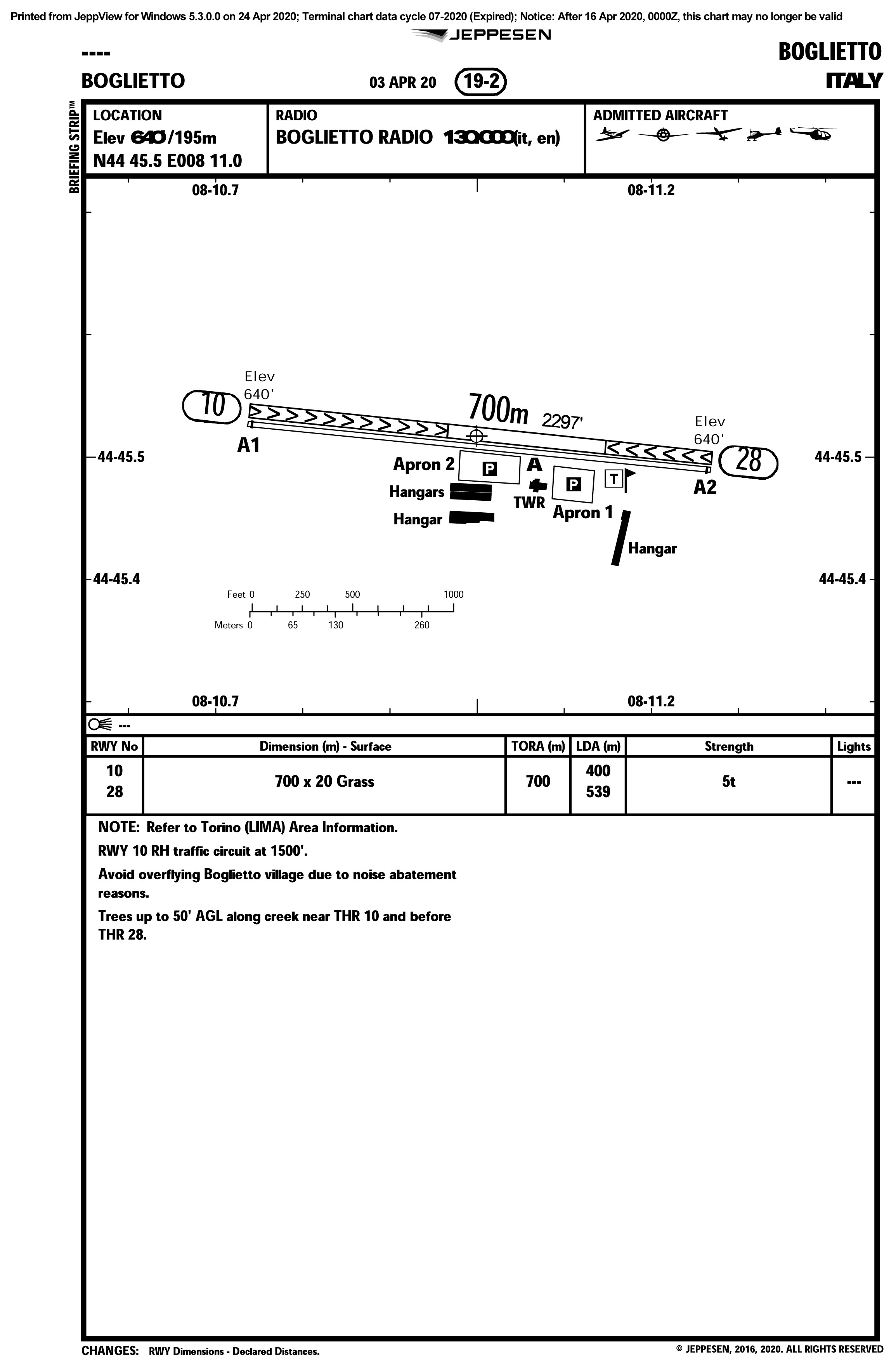
Orientamento pista / runway orientation: 10/28
No pendenza / no slope
Fondo / surface: erba / grass
Per atterrare è necessario richiedere preventivamente il consenso ai numeri seguenti / For landing, it is mandatory to obtain prior consent at these numbers:
- Gestore: +39 345.658.5968 (Ernesto)
- Presidente: +39 366.340.2164 (Lorenzo)
Altre Informazioni:
Other Info:
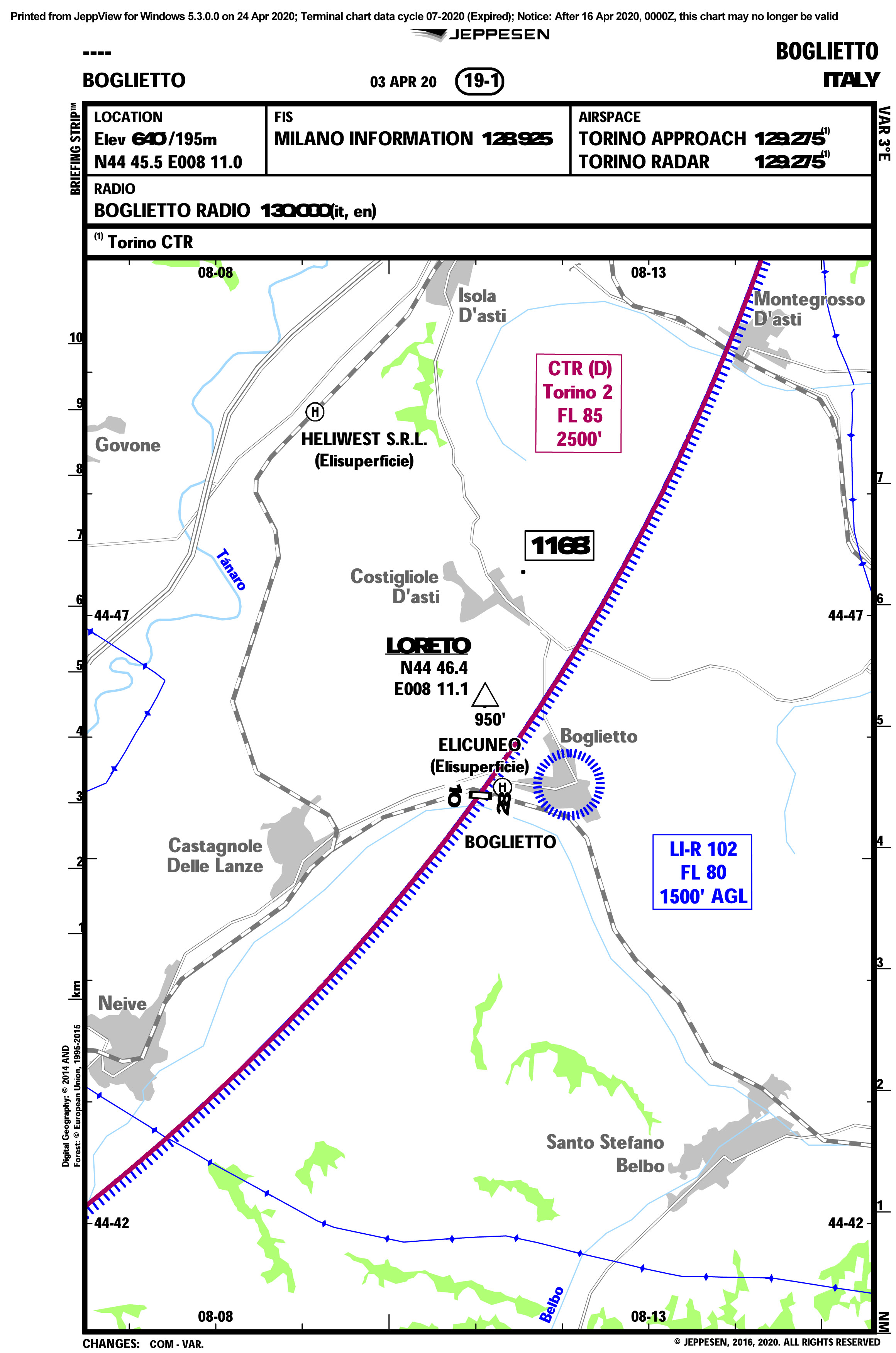
Circuito di traffico (valido per ogni tipo di velivolo):
- Pista 10 circuito destro 1500ft
- Pista 28 circuito sinistro (standard) 1500ft
Frequenza locale: Boglietto Radio 130.00mh/z
Distanze dichiarate:
- pista 10: TORA 700 mt LDA 420 mt
- pista 28: TORA 700 mt LDA 540 mt
- Larghezza pista: 20mt + striscia di sicurezza 10mt (entrambi i lati)
- Portata massima: SIWL 2.8tons (con pista asciutta)
Other Info:
Traffic circuit (valid for all types of aircraft):
- Rwy 10: right, 1500ft
- Rwy 28: left (standard), 1500ft
Radio frequency: Boglietto Radio 130.00mh/z
Declared distances:
- Runway 10: TORA 700mt LDA 420 mt
- Runway 28: TORA 700mt LDA 540mt
- Width rnw: 20mt + safety strip 10mt (both sides)
- Maximum load SIWL 2.8tons (dry rnw)
Note operative:
- Presenza di alberi (50ft) presso entrambi i fine pista e sul lato nord della stessa
- Pista in ambiente collinare. Attenzione: in inverno il fondo valle entra in ombra (circa 30' prima della scadenza delle effemeridi)
- In presenza di vento dal quadrante Nord oltre i 15 nodi, possibilità di turbolenza in finale per entrambe le direzioni di atterraggio
- Vietato il sorvolo della frazione di Boglietto sotto i 1500 ft
- La safety area per pista 28 sul lato destro si riduce fino ad annullarsi negli ultimi 200mt di pista
- Mantenere sempre l'ascolto su 130.00 per eventuali informazioni di traffico riguardante il circuito elicotteri di Elicuneo posto a Nord del campo
- Per l'atterraggio, è sempre obbligatorio contattare i seguenti numeri, per ottenere il consenso preventivo e per ricevere informazioni aggiornate sullo stato operativo dell'aviosuperficie:
- Gestore: +39 345.658.5968 (Ernesto)
- Presidente: +39 366.340.2164 (Lorenzo)
- Per eventuali emergenze:
- 112 (generale)
- 115 (VVFF)
- Croce rossa Costigliole 0141 961919
- Carabinieri Costigliole 0141 966096
- Possibilità di consultare le webcam per vista pista sul sito www.avioboglietto.it
- Per i velivoli di AG ricordarsi di compilare il registro dei movimenti presso la clubhouse
Operational Notes:


- Presence of trees (50ft) near both ends of the runway and along the north side
- Runway in a hilly environment. Caution: in winter, the valley floor falls into shadow (about 30' before sunset)
- With north quadrant winds over 15 knots, possibility of turbulence on final approach for both landing directions
- Overflight of the Boglietto area below 1500 ft is prohibited
- The safety area for runway 28 on the right side decreases to zero in the last 200 meters of the runway
- Always monitor 130.00 for any traffic information regarding the Elicuneo helicopter circuit to the north of the field
- For landing, it is always mandatory to contact the following numbers to obtain prior consent and to get updated information on the operational status of the airfield:
- Manager: +39 345.658.5968 (Ernesto)
- President: +39 366.340.2164 (Lorenzo)
- For emergencies:
- 112 (general emergency)
- 115 (fire brigade)
- Croce rossa (sanitary) Costigliole 0141 961919
- Carabinieri (military police) Costigliole 0141 966096
- Possibility to check the webcams for runway view on the website www.avioboglietto.it
- AG aircraft must fill in the movement log at the clubhouse
Webcam
Le immagini sono aggiornate ogni 30 minuti / Images are updated every 30 minutes.Documentazione / More information
